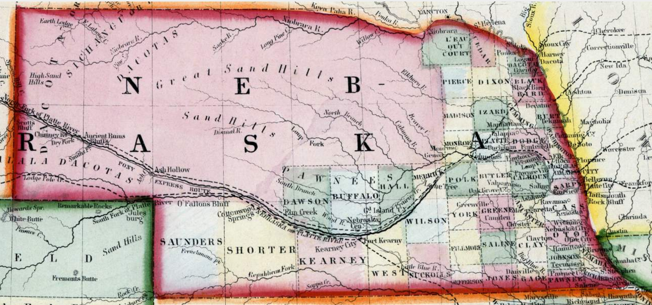
Not too long ago, we came across an 1861 map of Nebraska -- when the Cornhusker State was still just a territory, not state. (Click on the map for a closer look.)
Just a few years before the 1861 map was printed, the Nebraska Territory had encompassed what is today six or seven separate states. But by the late 1850s, Nebraska had taken the physical form of the familiar shape we call home today.
What makes this 1861 map significant is that even as the U.S. and Confederacy were preparing for war, triggered in part by the Nebraska-Kansas Act, many Nebraska counties had already been formed. In fact, six years before Nebraska would become a state, about half of today's 93 counties were already in existence.
Many of those counties had different names than they have today. For example, today's Jefferson County was Jones County.
Today's Thayer County was Jefferson County.
To our north, present-day Seward County was Greene County.
To our north, present-day Seward County was Greene County.
Saunders County -- which today contains communities like Wahoo -- back then was a large patch of real estate located in the far southwestern corner of today's state boundaries, in the area of present-day McCook.
Clay County was crunched between Lancaster and Gage.
There were also some counties with some unfamiliar names, like Shorter, Izard, Black Bird, and L'eau Out Court counties.
There were also some counties with some unfamiliar names, like Shorter, Izard, Black Bird, and L'eau Out Court counties.
And several counties in 1861 had much different geographical boundaries than they do today. Lancaster County, for example, was only half its modern-day size. Same is true for Gage.
But Saline County today is pretty much the same county -- geographically anyway -- that appeared on the 1861 map. That's a bragging right that not many Nebraska counties can claim.
But Saline County today is pretty much the same county -- geographically anyway -- that appeared on the 1861 map. That's a bragging right that not many Nebraska counties can claim.
Congratulations, Saline County. You're a true original.


No comments:
Post a Comment
Village Dweller checks all reader comments to determine if they are appropriate for print.